| Card n. | Description | Locality | Linked sites |
| 58 | Borgo Prà | Belluno | 37 |
| file .pdf | Architecture Art History (ASA) - Ethnographic Sites (SE) | Google maps |
 |
- Description
- How to get there
- Interesting facts
- Bibliography
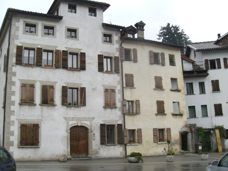
The development of Borgo Prà is closely linked to two particular facts: the first, both logical and natural, was the presence of the bridge built here to cross the Ardo for reasons of trade, while the second is connected to the decision, in 1378, to transfer the ancient Fair of San Lucano to an area free of buildings, close to the town but not right next to it. The same year saw the repair of the bridge over the Ardo, which throughout its history was to undergo continual rebuilding and strengthening work as a result of the unpredictable behaviour of the rushing waters of the torrent. The bridge was known as the “Paglia” (straw) bridge, because of its characteristic roof, necessary because from the very beginning it was compulsory to pay a toll and a duty to cross it. Initially, the flat part of the neighbourhood, towards the Ardo, was left as a field without buildings, the first of which were built in the north-eastern part. Most of the activities carried out there in the 15th, 16th and 17th centuries were linked to iron working and sword making, and later to materials for the artillery. Iron and steel working was made possible as a result not only of the nearby trade route that came down from Zoldo and La Valle Agordina and was linked to the supply of raw materials, but also of the roia, the irrigation channel that provided water to the mills and was fed by the waters of the Ardo upstream at Fisterre. This channel was particularly complex, featuring little bridges and sharp turns created to make the water flow faster and ensure it did not run out of energy at Borgo Prà and was able to supply power to the mills of Borgo Piave. A so-called “channel bridge”, which transported the water from the left to the right bank of the river, was demolished in the 1970s. Borgo Prà was home to a flourishing community of marangoni, or carpenters, to whom the church – originally consecrated to the Beata Vergine del Buon Consiglio – is now dedicated. Piazza San Lucano, the beating heart of the neighbourhood, has suffered significant damage on the south side, because one of its older buildings was demolished to make way for a road, thus ruining the smooth visual effect that made the square look not unlike a large courtyard. On the whole, however, the neighbourhood has maintained its distinctive community appearance.
After the Belluno Sud exit of the A27 (on the left of the Piave), cross the Dolomiti Bridge and along Via Sarajevo and Via Lungardo until you reach the small bridge over the Ardo. After the torrent, turn right on the bridge into the little square in Borgo Prà.
From the Belluno Nord exit, go along Via Vittorio Veneto; at the roundabout, continue following the top of the bell tower of San Pietro, and go down until you reach the so-called Ponte Nuovo, or New Bridge; at the roundabout, take Via San Biagio and go down towards the Ardo; after a rather tight bend, you will see the bridge on your left.
ACCESSIBLE: yes
MUNICIPALITY: Belluno
PLACE: Borgo Prà
GEOGRAPHICAL COORDINATES: X 1748862 – Y 5114822
PROVINCE: Belluno
FILE COMPILED BY: Visentin/Vallerani
Across the bridge over the Ardo, along the slope that leads up to the Ponte Nuovo bridge, is the oldest church of the Christian community in Belluno: Santa Croce in Campestrino, the present-day San Biagio, with a Greek cross ground plan and a very simple, attractive structure. Here, in the 12th century, a hospice was also built for the sick and for wayfarers travelling along the nearby road to the Cadore.
M. Cassol, L. Facchin, Itinerario lungo il corso d’acqua dalla città di Belluno al Parco Nazionale delle Dolomiti Bellunesi, Belluno, 1993
M. Dal Mas, Pra: Storia di un borgo, Belluno, 1978
