| Card n. | Description | Locality | Linked sites |
| 85 | Mills Route in Cison | Cison di Valmarino | 176 - 166 |
| Ethnographic Sites (SE) |
Google maps |
 |
 |
 |
- Description
- How to get there
- Interesting facts
- Bibliography
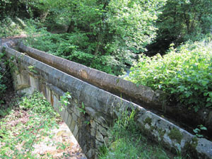
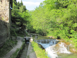
The old water mills are clearly visible along the equipped path that runs alongside the little Rujea, an irrigation channel on the left bank of the Rujo torrent. Further along, in the Capretta-Mugnai neighbourhood, north of the centre of Cison, where the irrigation channel runs underground for a stretch, you can see two buildings, which were once the Masutti mill and the dairy next to it. Continuing northwards, the route runs past a building that was once a fulling plant and from there on to the water-powered mills of the Campo Molino area at Bosc de Fol. Here you can see the Moret mills, and, further up, the Fiorin mill, with a red iron wheel on the western wall and a large washtub next to it. After crossing through the ruins of another mill, the path continues towards the bridge-canal of San Silvestro, next to the irrigation channel. Not far from this structure, rebuilt in 1997, are the Cencio Ciae mills. Situated on a slope on the right of the Rujo, these mills were powered by the imposing waterfall of the irrigation channel: supported by a massive wall, the channel, now on the right bank, was once at a considerable height from the bed of the Rujo, and this level difference was sufficient to set in motion two wheels for milling. The route, well signposted and provided with information panels, also has a northern offshoot towards the “Bujon del Gal” that is of particular interest to nature lovers. The mills, which are now either abandoned or have been turned into private homes, were already in business during the Middle Ages, and were restored by the noble Brandolini family, who also turned Cison castle into a noble palace in the 17th century.
From the Vittorio NORD exit of the A27, take the SP35 road that runs between Vittorio and Cison-Follina; this road provides easy access both to the clearly signposted Revine Lakes and to the village of Cison further ahead. Take the road on the left that leads to the village and park there, then continue on foot along the left bank of the Rujo. There are plenty of signs for tourists in the area.
ACCESSIBLE: yes
MUNICIPALITY: Cison di Valmarino
PLACE: Campo Molino
GEOGRAPHICAL COORDINATES: X 1743605 - Y 5095480
PROVINCE: TV
FILE COMPILED BY: Bonato
In Tovena, between Cison and Revine, a winding route begins that leads towards the San Boldo pass, frequented over the centuries by raftsmen, merchants and local stock farmers, who used either this route or the Praderadego pass or the route above S. Martino and Guia towards Stabie (Volt de’ l’Arc) to get back to the Valbelluna.
The nearby Revine lakes (NS 166) are divided up into two basins that were once joined together: Lago lake to the west and the smaller Santa Maria lake. The area around the lakes was inhabited as far back as prehistoric times, as is attested to by the discovery and philological and educational reconstruction of a village from the period.
M. Cassol, D. Dal Zotto, Le vie dell’acqua. Alla scoperta di un territorio, Belluno, 2007
Various Authors, Cison di Valmarino e il suo passo, il San Boldo attraverso i secoli, Pieve di Soligo, 2004
Various Authors, Il Rujo. Itinerari tra natura e storia, “Al Mazarol” cultural circle and “La Via dei Mulini” association, Cison di Valmarino, 2002 (leaflet)
Various Authors, La via Claudia Augusta, reprint, with comments, of the Studies by De Bon (1938), Venice, 2001
Various Authors, Il Veneto paese per paese, Bonechi, Florence, 1998
