| Card n. | Description | Locality | Linked sites |
| 38 | San Lucano Valley | Taibon Agordino | 160 - 127 |
| file .pdf | Naturalistic Interest Sites (SIN) | Google maps | 89 |
 |
 |
 |
- Description
- How to get there
- Interesting facts
- Bibliography
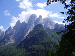
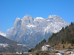
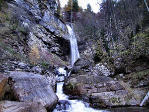
The San Lucano valley is about 8 km long, and is flanked by Monte Agner and the Pale di San Lucano. The waters of the Tegnàs torrent flow copiously, and the vegetation is varied, since the altitude ranges from 800 metres at the valley bottom up to the almost 3000 metres of the peaks. Numerous bivouacs and refuges have been repaired and restored in recent years, creating an effective network of accommodation facilities for hikers. About halfway along the gorge is the church dedicated to San Lucano, presumed to have been the bishop of Sabiona in the South Tyrol, and better known as the apostle of the Dolomites. According to tradition, the bishop carried out his pastoral activity in these areas crossed by the ancient road that linked the valleys of the Piave and the Adige, and died in poverty as a hermit in the 5th century A.D.; his remains were then taken to Belluno, in the church dedicated to him, in Carolingian times. Next to the building is a recently restored hermitage, used as a meeting place. Along the flow of the Tegnàs, in the first half of the 20th century, the San Lucano hydroelectric plant was built, the water uptake system of which is situated downstream from the little church of the same name. From the power plant, a second pipe channels the water of the Tegnàs towards the Gnech power plant, located just downstream from the Toccol power plant, one of the leading ENEL plants in the hydroelectric system of the Cordevole (see file no. 127 – 89).
The San Lucano valley can be reached by going along the SR203 Agordina. After the town of Agordo, continue until km 29.1, and follow (on the left) the road signs for the village of Taibon Agordino, which you will find after you cross a bridge over the Cordevole. From the centre of the village follow the tourist signs for the San Lucano valley, which runs along the flow of the Tegnàs torrent.
ACCESSIBLE: yes
MUNICIPALITY: Taibon Agordino
PLACE: San Lucano Valley
GEOGRAPHICAL COORDINATES: X 1731889 - Y 5132147
PROVINCE: Belluno
FILE COMPILED BY: Visentin/Rossi
In 1926, in Nogarola di Taibon, on the left of the Cordevole, the Società Anonima Pasta Legno ed Elettrica was set up to produce paper. It remained in operation until 1981, by which time most paper was made using cellulose.
Near the bridge over the Cordevole, in the centre of Taibon, also worth a visit is the Church of San Cornelio and San Cipriano.
A few kilometres from Taibon Agordino is the Listolade Battery, better known as the “Pèden Fort”, built at the end of the 19th century at the foot of Monte San Lucano for wartime control over the narrow of Listolade and movements from the Val Corpassa. It can be reached along a convenient military road that sets out from Taibon and is characterised by huge dry stone walls. Although overgrown with vegetation, the fort is worth a visit to admire its interesting architectural and military features.
G. Gullino, Storia di Belluno. Dalla preistoria all’età contemporanea, Sommacampagna, 2009
Comunità Montana Agordina, Guida storico-escursionistica ai luoghi della Grande Guerra. I luoghi della Grande Guerra in Provincia di Belluno: interventi di recupero e valorizzazione nei territori del Parco della memoria, Agordo, 2005
E. De Biasio, Pale di San Lucano, Cimolais, 2004
